![9120980129_c6b3b8c789[1]](http://0129.org/wp-content/uploads/2014/05/9120980129_c6b3b8c7891.jpg)
Image by james_gordon_losangeles
Mesa Verde National Park is a U.S. National Park and UNESCO World Heritage Site located in Montezuma County, Colorado, United States. It is the largest archaeological preserve in the United States. The park was created in 1906 by President Theodore Roosevelt, to protect some of the best-preserved cliff dwellings in the world, or as he said, “preserve the works of man”. As a result it is the first and still only cultural National Park set aside by the National Park System. It occupies 81.4 square miles (211 km2) near the Four Corners and features numerous ruins of homes and villages built by the Ancestral Puebloan people, sometimes called the Anasazi. There are over four thousand archaeological sites and over six hundred cliff dwellings of the Pueblo people at the site.
The Anasazi inhabited Mesa Verde between 600 to 1300, though there is evidence they left before the start of the fifteenth century. They were mainly subsistence farmers, growing crops on nearby mesas. Their primary crop was corn, the major part of their diet. Men were also hunters, which further increased their food supply. The women of the Anasazi are famous for their elegant basket weaving. Anasazi pottery is as famous as their baskets; their artifacts are highly prized. The Anasazi kept no written records.
By the year 750, the people were building mesa-top villages made of adobe. In the late 1190s, they began to build the cliff dwellings for which Mesa Verde is famous.
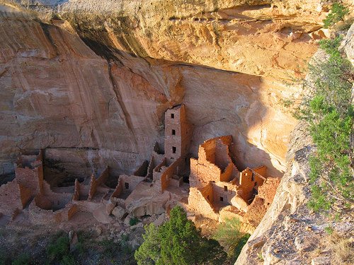
Mesa Verde is best known for cliff dwellings, which are structures built within caves and under outcropping in cliffs — including Cliff Palace, thought to be the largest cliff dwelling in North America. The Spanish term Mesa Verde translates into English as “green table”. It is considered to contain some of the most notable and best preserved archaeological sites.
Geography and climate
Mesa Verde National Park, with fifty-two thousand acres, is located in the southwestern Colorado. Its canyons were created by erosion from receding ancient oceans and waterways, which resulted in Mesa Verde National Park elevations ranging from about 6,000 to 8,572 feet (1,800 to 2,613 m), the highest elevation at Park Point. The terrain in the park is now a transition zone between the low desert plateaus and the Rocky Mountains.
The climate is semi-arid. Water for farming and consumption by the Ancient Pueblo Peoples was provided by summer rains, winter snowfall and seeps and springs in and near the Mesa Verde villages. The middle mesa areas, ten degrees cooler than on the mesa at 7,000 feet (2,100 m), were ideal for agriculture, and the lower temperatures reduced the amount of water needed for agriculture. The cliff dwellings were built with obvious attention to managing solar energy. In the winter, the angle of the sun warmed the masonry of the cliff dwellings, warm breezes blew from the valley, and the air was ten to twenty degrees warmer in the canyon alcoves than on the top of the mesa. In the summer, due to the angle of the sun, much of the village was protected from direct sunlight in the cliff dwellings.
By 1300 AD prolonged drought had caused the fragile adaptation to collapse and the Mesa Verde area was abandoned. The surviving Mesa Verde people retreated to the south and east.
Geologic history
In the late Cretaceous Period, the Mancos Shale was deposited on top of the Dakota Sandstone, which is the rock formation that can be found under much of Colorado. The beds of the Mancos Shale are “fine-grained sand-stones, mudstones, and shales” which accumulated in the deep water of the Cretaceous Sea. It has a high clay content which causes it to expand when wet leading to sliding of the terrain.
On top of this shale, there are three formations in the Mesaverde group which reflect the changes in depositional environment in the area over time. The first is the Point Lookout Sandstone, which is named for the Point Lookout feature in the park (elevation 8427 feet). This sandstone—which formed in the marine environment of shallow water when the Cretaceous sea was receding—is “massive, fine-grained, cross-bedded, and very resistant”, in its layers reflecting waves and currents that were present during the time of its formation. Its sediments are approximately 400 feet thick, and its upper layers feature fossiliferous invertebrates.
Next is the Menefee Formation, the middle formation whose content features “interbedded carbonaceous shales, siltstones, and sandstones”. These were deposited in a semi-marine environments of brackish water in “bays, lagoons, and swamps”. Due to its depositional environment and the organic material in its composition, there are thin coal seams running through the Menefee Formation. At the top, this Formation is intruded upon or “inter fingers with” the Cliff House Sandstone.
The Cliff House Sandstone is the “youngest rock layer present in the area.” It was formed after the Cretaceous sea had completely receded and as a result has a high sand content from beaches, dunes, etc. and from this receives its characteristic yellow tint to its canyon faces. Like the Point Lookout Sandstone, it is about 400 feet thick. It contains numerous fossil beds of different types of shells, fish teeth, and other invertebrate leftovers from the receded sea. The shale zones in this feature determine where alcoves formed where the Anasazi Indians constructed their dwellings.
Continuing through the Cretaceous period and into the early Tertiary, there was uplifting in the area of the Colorado Plateaus, the San Juan Mountain, and the La Plata Mountain which led to the formation of the Mesa Verde pediment with the help of erosion. Small channels of water ran across this formation depositing gravel. Later in the tertiary, the last period of uplift and rock tilting towards the south caused these streams to cut rapidly into the rock removing loose sediment and forming the vast canyons seen today. This caused the isolation of the Mesa Verde pediment from surrounding rock. Today, since the climate is more arid, these erosional processes are significantly slowed.
History
Mesa Verde residents
The Mesa Verde area was settled by 400 AD, and villages subsequently spread into a variety of local ecological settings. Over time masonry replaced jacal walls and central villages came to dominate smaller subordinate ones scattered around them in multivillage polities.
Modified Basketmakers AD 550 to 750
This era resulted in the introduction of pottery, which reduced the number of baskets that they made and eliminated the creation of woven bags. The simple, gray pottery allowed them a better tool for cooking and storage. Beans were added to the cultivated diet. They replaced spears and atlatls with bows and arrows, which made hunting easier, and thus the acquisition of hides for clothing. Turkey feathers were woven into blankets and robes. On the rim of Mesa Verde, small groups built pit houses several feet below the surface with elements suggestive of the introduction of celebration rituals.
Developmental Pueblo AD 750 to 1100
Pueblo buildings were built with stone, windows facing south, and in U, E and L shapes. The buildings were located more closely together and reflected deepening religious celebration. Towers were built near kivas and likely used for lookouts. Pottery became more versatile, including pitchers, ladles, bowls, jars and dishware for food and drink. White pottery with black designs emerged, the pigments coming from plants. Water management and conservation techniques, including the use of reservoirs and silt-retaining dams, also emerged during this period.
Like the people at Hovenweep National Monument and Canyon de Chelly National Monument, about AD 1100, the Mesa Verde village communities moved from mesa tops to the heads of canyons.
Great Pueblo period AD 1100 to 1300
Architecture
Section view of Kiva A in Mesa Verde’s Fire Temple, cut from laser scan data collected by a CyArk/National Park Service partnership. Since Fire Temple was at least partially built to conform to the dimensions of the cliff alcove in which it was built, it is neither round in form nor truly subterranean like other structures generally defined as kivas.
Mesa Verde is best known for a large number of well-preserved cliff dwellings, houses built in shallow caves and under rock overhangs along the canyon walls. The structures contained within these alcoves were mostly blocks of hard sandstone, held together and plastered with adobe mortar. Specific constructions had many similarities but were generally unique in form due to the individual topography of different alcoves along the canyon walls. In marked contrast to earlier constructions and villages on top of the mesas, the cliff dwellings of Mesa Verde reflected a region-wide trend towards the aggregation of growing regional populations into close, highly defensible quarters during the AD 1200s.
While much of the construction in these sites conforms to common Pueblo architectural forms, including kivas, towers, and pit-houses, the space constrictions of these alcoves necessitated what seems to have been a far denser concentration of their populations. Mug House, a typical cliff dwelling of the period, was home to around 100 people who shared 94 small rooms and eight kivas built against each other and sharing many of their walls; builders in these areas maximized space in any way they could, with no areas considered off-limits to construction.
Not all of the people in the region lived in cliff dwellings; many colonized the canyon rims and slopes in multi-family structures that grew to unprecedented size as populations swelled. Decorative motifs for these sandstone/mortar constructions, both surface and cliff dwellings, included T-shaped windows and doors. This has been taken by some archaeologists, such as Stephen H. Lekson, as evidence of the continuing reach of the Chaco Canyon elite system, which had seemingly collapsed around a century before. Other researchers see these motifs as part of a more generalized Puebloan style and/or spiritual significance, rather than evidence of a continuing specific elite socioeconomic system.
The buildings that were built here showed a trend at the time of inhabitants moving towards time masonry techniques over former jacal walls that were commonplace in architectural design. One of the reasons settlers moved into the cliff dwellings was to increase their farming production by creating irrigation systems as water flowed down the cliff to attempt to combat the changing, drought induced, climate.
Migration from Mesa Verde
These construction and water-related activities lead archaeologists to speculate that climatic change and increased population placed the communities under stress. The ancient people of Mesa Verde left the area in the late 1200s, possibly in response to a 24-year regional drought. People in the entire Four Corners region were also abandoning smaller communities at that time, and the area may have been nearly empty by AD 1300. Having left the Mesa Verde area, the people of Mesa Verde moved south to southern Arizona and New Mexico.
Since then, there is evidence of Native Americans hunting in the Mesa Verde area. There is no evidence, though, that anyone lived in the cliff dwellings or pueblos after the Ancient Puebloan people.
Notable sites
PuebloPhotoComments
Balcony HouseSet on a high ledge facing east, Balcony House with 45 rooms and 2 kivas, would have been cold for its residents in the winter. The modern visitor enters by climbing a 32-foot ladder and a crawling through a 12-foot tunnel. The exit, a series of toe-holds in a cleft of the cliff, was believed to be the only entry and exit route for the cliff dwellers, which made the small village easy to defend and secure. One log was dated at AD 1278 so it was likely built not long before the Mesa Verde people migrated out of the area. It was officially excavated by Jesse Nusbaum, one of the first Superintendents of Mesa Verde National Park, in 1910. Visitors can enter Balcony House through ranger-guided tours.
This photo is of Emmett Harryson, a Navajo, at a T-shaped doorway at Balcony House (1929).
Cliff PalaceThis multi-storied ruin, the largest and best-known of the cliff dwellings in Mesa Verde, is located in the largest cave in the center of the Great Mesa. It was south- and southwest-facing, providing greater warmth from the sun in the winter. The site had 200 rooms, including storage rooms, open courts, walkways, and 23 kivas. Dating back more than 700 years, the dwelling is constructed of sandstone, wooden beams, and mortar. Many of the rooms were brightly painted.
Long HouseLocated on the Wetherill Mesa, Long House is the second-largest village, for about 150 people. The location was excavated as part of the Wetherhill Mesa Archaeological Project during the years 1959 through 1961. The 150 rooms are not clustered like the standard cliff dwellings, and they are not one of the most elegant set of buildings. Stones were used without shaping for fit and stability. Two overhead ledges contain more rooms. One ledge seems to include an overlook with small holes in the wall to see the rest of the village below. A spring is accessible within several hundred feet and seeps are located in the rear of the village. Long Houses were structures designed to expand as needed to hold large extended families.
Mesa Verde ReservoirsThese ancient reservoirs, built by the Ancient Puebloans, on September 26, 2004, became a National Civil Engineering Historic Landmark.
Mug HouseThis ruin situated on Wetherill Mesa contains 94 rooms, a large kiva, and a nearby reservoir. It received its name from four mugs the Charles Mason and the Wetherill brothers found strung together on a string. This ceremonial structure has a keyhole shape, due to a recess behind the fireplace and a deflector, that is considered an element of the Mesa Verde style. The rooms clustered around the kiva formed part of the courtyard, indicating the kiva would have been roofed.
Oak Tree HouseOak Tree House and neighboring Fire Temple can be visited via a 2-hour ranger-guided hike.
Spruce Tree HouseSpruce Tree House is the third-largest village, within several hundred feet of a spring, and had 130 rooms and eight kivas. It was constructed sometime between AD 1211 and 1278. It is believed anywhere from 60 to 80 people lived there at one time. Because of its protective location, it is well preserved. The short trail to Spruce House begins at the Chapin Mesa Archeological Museum.
Square Tower HouseThe Square Tower House is one of the stops on the Mesa Top Loop Road driving tour.[25] The tower that gives this site its name is the tallest structure in Mesa Verde. This cliff dwelling was occupied between AD 1200 and 1300.[citation needed] Square Tower House was the tallest man-made structure in the United States of America until mid 1800s.
Approximately 600 of the over 4700 archeological sites found in Mesa Verde National Park are cliff dwellings. In addition to the cliff dwellings, Mesa Verde boasts a number of mesa-top ruins.
Examples open to public access include the Far View Complex and Cedar Tree Tower on Chapin Mesa, and Badger House Community, on Wetherill Mesa.
Discovery
Ute
The area in and around Mesa Verde had been home to the Utes. In 1868, a treaty between the United States government and the Ute tribe recognized Ute ownership of Colorado land by identifying land west of the Continental Divide as Ute land. After there had become an interest in land in western Colorado, a new treaty in 1873 left the Ute with a strip of land in southwestern Colorado between the border with New Mexico and 15 miles north. Most of Mesa Verde lies within this strip of land. The Ute wintered in the warm, deep canyons and found sanctuary there and the high plateaus of Mesa Verde. Believing the cliff dwellings to be sacred ancestral sites, they did not live in the ancient dwellings.
Spanish explorers
Mexican-Spanish missionaries and explorers Francisco Atanasio Domínguez and Silvestre Vélez de Escalante, seeking a route from Santa Fe to California, faithfully recorded their travels in 1776. They reached the Mesa Verde (green plateau) region, which they named after its high, tree-covered plateaus, but they never got close enough, or into the needed angle, to see the ancient stone villages. They were the first white men to travel the route through much of the Colorado Plateau into Utah and back through Arizona to New Mexico.
1870s and 1880s American visitors[edit]
Occasional trappers and prospectors visited, with one prospector, John Moss, making his observations known in 1873.
The following year, he led eminent photographer William Henry Jackson through Mancos Canyon, at the base of Mesa Verde. There, Jackson both photographed and publicized a typical stone cliff dwelling.
In 1875, geologist William H. Holmes retraced Jackson’s route.
Reports by both Jackson and Holmes were included in the 1876 report of the Hayden Survey, one of the four federally financed efforts to explore the American West. These and other publications led to proposals to study Southwestern archaeological sites systematically.
Virginia McClurg, a journalist for the New York Daily Graphic, visited Mesa Verde in 1882 and 1885 in her quest to find Ancient Pueblo settlements. In 1885, her party found Echo Cliff House, Three Tier House and Balcony House, and these findings induced her future work to protect the dwellings and artifacts.
A family of cattle ranchers, the Wetherills, befriended members of the Ute tribe near their ranch southwest of Mancos, Colorado. With the Ute tribe’s approval, the Wetherills were allowed to bring cattle into the lower, warmer plateaus of the present Ute Mountain Ute Tribe in the winter. Word had spread of the dwellings of Ancient Pueblo people. Acowitz, a member of the Ute tribe, told the Wetherills of a special dwelling in Mesa Verde: “Deep in that canyon and near its head are many houses of the old people – the Ancient Ones. One of those houses, high, high in the rocks, is bigger than all the others. Utes never go there, it is a sacred place.”[8]:79[16] On December 18, 1888, Richard Wetherill and Charlie Mason, cowboys from Mancos, found Cliff Palace in Mesa Verde after spotting the ruins from the top of the mesa. Wetherill gave the ruin its present-day name. Richard Wetherill, family and friends explored the ruins and gathered artifacts, some of which they sold to the Historical Society of Colorado and much of which they kept.
Among the people who stayed with the Wetherills and explored the cliff dwellings was mountaineer, photographer, and author Frederick H. Chapin, who visited the region during 1889 and 1890. He described the landscape and ruins in an 1890 article and later in an 1892 book, The Land of the Cliff-Dwellers, which he illustrated with hand-drawn maps and personal photographs.
Gustaf Nordenskiöld
The Cliff Palace in 1891, photo by Gustaf Nordenskiöld.
The Wetherills also hosted Gustaf Nordenskiöld, the son of polar explorer Adolf Erik Nordenskiöld, in 1891. Nordenskiöld was a trained mineralogist who introduced scientific methods to artifact collection, recorded locations, photographed extensively, diagrammed sites, and correlated what he observed with existing archaeological literature as well as the home-grown expertise of the Wetherills. He removed a lot of artifacts and sent them to Sweden, where they eventually went to the National Museum of Finland. Nordenskiöld published, in 1893, The Cliff Dwellers of the Mesa Verde. When Nordenskiöld shipped the collection that he made of Mesa Verde artifacts, the event initiated concerns about the need to protect Mesa Verde land and its resources.
National Park
Becoming a National Park[edit]
Virginia McClurg was diligent in her efforts between 1887 and 1906 to inform the United States and European community of the importance of protecting the important historical material and dwellings in Mesa Verde. Her efforts included enlisting support from 250,000 women through the Federation of Women’s Clubs, writing and having published poems in popular magazines, giving speeches domestically and internationally, and forming the Colorado Cliff Dwellers Association. The Colorado Cliff Dwellers’ purpose was to protect the resources of Colorado cliff dwellings, reclaiming as much of the original artifacts as possible and sharing information about the people who dwelt there. A fellow activist for protection of Mesa Verde and prehistoric archaeological sites included Lucy Peabody, who, located in Washington, D.C., met with members of Congress to further the cause.[6][8]:85[29]:61-72
Former Mesa Verde National Park superintendent Robert Heyder communicated his belief that the park might have been far more significant with the hundreds of artifacts taken by Nordenskiöld.
J. Walter Fewkes at Mesa Verde cliff dwellings, circa 1910.
By the end of the 19th century, it was clear that Mesa Verde needed protection from people in general who came to Mesa Verde and created or sold their own collection of artifacts. In a report to the Secretary of the Interior, Smithsonian Institute Ethnologist J. Walter Fewkes described vandalism at Mesa Verde’s Cliff Palace:
Parties of “curio seekers” camped on the ruin for several winters, and it is reported that many hundred specimens there have been carried down the mesa and sold to private individuals. Some of these objects are now in museums, but many are forever lost to science. In order to secure this valuable archaeological material, walls were broken down often simply to let light into the darker rooms; floors were invariably opened and buried kivas mutilated. To facilitate this work and get rid of the dust, great openings were broken through the five walls which form the front of the ruin. Beams were used for firewood to so great an extent that not a single roof now remains. This work of destruction, added to that resulting from erosion due to rain, left Cliff Palace in a sad condition.